




💧 Sikvaruli Waterfall: A Heart-Shaped Cave Right at the Entrance to Ambrolauri
💧 Sikvaruli Waterfall at the Edge of Ambrolauri
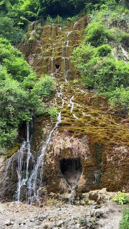
A small waterfall right at the entrance to Ambrolauri, known not for its height but for its shape: water falls from a heart-shaped opening in a moss-covered rock. "Sikvaruli" translates from Georgian as "love." It's easy to reach, with little to no walking required, unusual for a natural site in Racha.
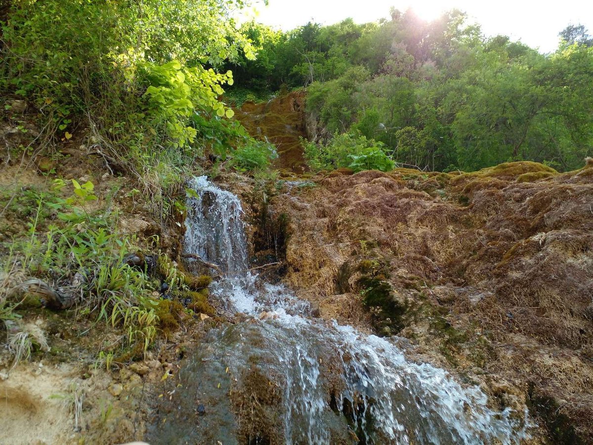
Sikvaruli Waterfall, or the Waterfall of Love, stands right at the entrance to Ambrolauri, the administrative center of Racha, on Gurgeniani street. Water falls from an opening in a moss-covered rock that genuinely reads as a heart shape, hence the name: "sikvaruli" means "love" in Georgian. It's a rare case among Racha's natural sites where you don't need to set aside half a day for the approach, the waterfall is literally on the edge of town.
The site is compact, without a dramatic drop, and it's worth saying that upfront so no one is disappointed: people come here not for scale but for one specific, recognizable shot.
💚 Why "Waterfall of Love": A Heart-Shaped Cave
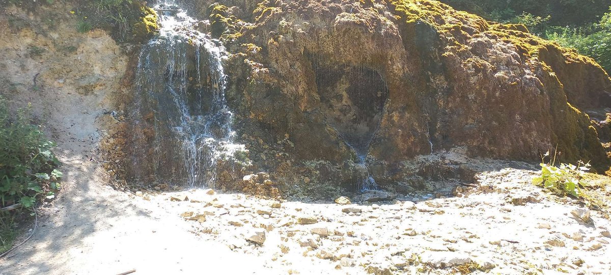
The main reason people come here is the shape of the small cave opening the water flows from. The outline genuinely reads as a heart, especially when the surrounding rock is covered in moss and greenery and the water catches a light haze in the sun. As far as available sources show, there's no elaborate legend here with names and a tragic backstory, the name appears to describe quite literally what you'll see.
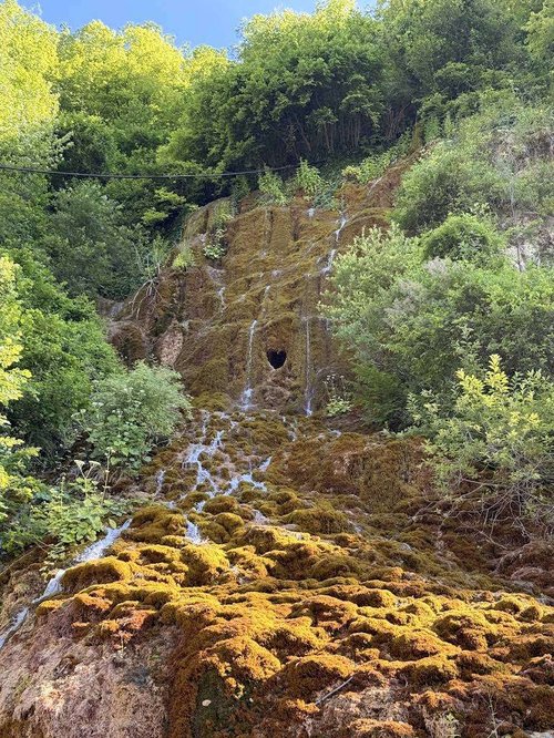
Sometimes the most honest story is the absence of drama: the place was named for what it looks like, and that turned out to be enough to make it one of Racha's signature spots for romantic and family trips over the decades.
🌿 What You'll Actually See
The rock around the source is thickly covered in moss, so the water seems to flow straight out of a green wall. The cave opening is low, you can look inside, but it's not a full cave to explore, more of a natural arch the water spills from. In summer it's noticeably cooler here than in open sun, thanks to the constant moisture and shade.
Based on reviews in the Madloba catalogue, impressions are honestly mixed, and it's worth knowing that in advance. Some visitors, especially Georgian speakers, describe the place as touching and quiet, with a sense of harmony by the water. Other reviews are more reserved, one visitor admitted expecting a bigger, more powerful flow, and found the waterfall more modest than hoped. Both are fair: this isn't Martvili or Kinchkha in scale, but the intimacy and the shape of the opening are exactly what make it memorable.
🗓️ The Waterfall by Season: What to Expect from the Flow
📸 When to Go and How to Shoot It
The moss on the rock stays green almost year-round thanks to the constant moisture near the source, and you can see how the flow itself changes season by season in the guide above.
For photos, it's best to avoid the harshest midday sun: hard light doesn't sit well on wet, dark rock and moss, and the shot ends up flat and overly contrasty. Soft morning or late-afternoon light brings out both the greenery and the shape of the heart.
🗺️ Sikvaruli Waterfall on the Map
Open in Google Maps🍷 What's Nearby
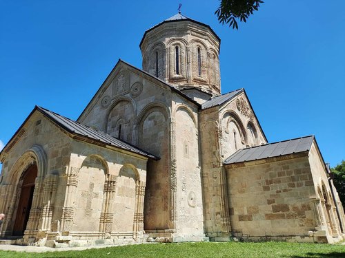
Ambrolauri is the heart of the Khvanchkara wine region, so the waterfall pairs easily with a tasting at a local winery. Nearby stands Nikortsminda Cathedral, one of Georgia's most recognizable 11th-century churches with rich stone carving, and right next to it, in the same-named village, the Udabno and Sakinule caves, with an arched spring and a glacial cave in the forest. Off toward the edge of town lies the Shaori Reservoir, and for those drawn to bigger mountains and legends, Mount Khvamli is worth a look, tied in Georgian tradition to the myth of Amirani, chained to the rock.
All of these fit into one relaxed day around Ambrolauri, and Sikvaruli Waterfall works well as a first or last stop, the detour takes very little time.
Sikvaruli Waterfall isn't trying to impress with scale, and that's the point. It's a small, instantly recognizable spot at the edge of town, easy to fold into a trip without a hike or any special preparation. Some people leave genuinely moved; others shrug and say they expected more. But the shape of that heart in the moss-covered rock is hard to forget either way.
Have you been to Sikvaruli Waterfall? Share in the comments on Madloba: did your impressions match your expectations, and what time of year did you visit?
Information is current as of July 2026. Water levels at the source change with the season, ask locally in Ambrolauri for current conditions before your trip.
📚 Read Next Racha and the area around Ambrolauri
❓Frequently Asked Questions
Right at the entrance to the town of Ambrolauri, on Gurgeniani street, in the Ambrolauri Municipality of the Racha-Lechkhumi and Kvemo Svaneti region.
Because of its shape: the water falls from an opening in the rock that resembles a heart. "Sikvaruli" means "love" in Georgian.
As far as available sources show, there's no elaborate legend with names and a backstory. The name appears to simply describe the shape of the cave.
No, this is a rare case among Racha's natural sites: the waterfall sits right by the road at the entrance to Ambrolauri, no long trail needed.
It's small, and visitor reviews are honestly mixed: some find it intimate and touching, others expected a more powerful flow. It works best combined with other stops around Ambrolauri, Khvanchkara wine, or Nikortsminda Cathedral.
No, entry is free, and there's no infrastructure like ticket booths or cafes on site.
In soft morning or late-afternoon light rather than harsh midday sun, that's when both the moss and the heart shape in the rock come through best.
The 11th-century Nikortsminda Cathedral, Khvanchkara wineries, Shaori Reservoir, and, for legend enthusiasts, Mount Khvamli with its myth of Amirani.
Read also
- Mravaldzali Lake: Heart Shape and Mountain Views in Racha
- Tobi Waterfall in Georgia: 234-Metre Cascade from a Cave
- The Cave, Waterfall and Boxwood Grove of Intsira: A Route Through Chkvaleri
- Tsoni Cave in Georgia: Highest Lower Palaeolithic Site at 2,100 m
- Route to Gega Waterfall Guide: Photos, Cave and Height

4 comments
Log in to leave a comment
إذا كنت تعتقد أن المناظر الطبيعية هنا هي مجرد خلفية، فأنت مخطئ. هناك شيئًا أكثر عمقًا، شيء يربطك بالأرض. أود أن أعرف، هل هناك مسارات مخفية أخرى في المنطقة يمكن اكتشافها، لأنني أشعر أنني بحاجة إلى العودة وتجربة المزيد؟