




💧 Silver Lakes of Samegrelo: A Guide to the Toba Lakes of the Egrisi Range
💧 The Toba Lakes at a Glance
A group of high-altitude lakes on the Egrisi Range in Samegrelo. "Toba" means "lake" in Megrelian, and the most famous of them, Tobavarchkhili, is the "silver lake". Remote, but stunningly beautiful.
Didgalish, Tsakatskarish, Kalalish, Okhoje and the distant Lakumurashi are the "family" of silver lakes around the main one, Tobavarchkhili. They're all covered in a single multi-day hike.
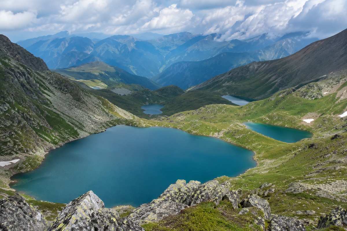
High on the Egrisi Range, deep in the Samegrelo region, hides a whole group of mountain lakes that locals call "toba", simply "lake" in Megrelian. The most famous of them is Tobavarchkhili, the "silver lake", and around it lies a whole family of smaller ones: Didgalish, Tsakatskarish, Kalalish, Okhoje and the distant Lakumurashi. All the region's natural sights are gathered in the catalog on the Natural Attractions of Samegrelo and Upper Svaneti page.
Let's clear up one important thing first. These lakes are often called "lakes of Svaneti" because they lie in the Samegrelo-Upper Svaneti region. But in fact they're on the Samegrelo side, on the Egrisi Range (also called the Samegrelo or Odishi range), within the bounds of Samegrelo National Park. So if you're planning a hike, the reference point is Samegrelo and Chkhorotsku, not the towered Svaneti with Mestia.
💎 What the Toba Lakes Are
The Toba lakes are a group of high-altitude lakes on the slopes of the Egrisi Range, scattered at altitudes of roughly 2,400 to 2,650 metres. Most are of glacial origin (for some lakes sources also name volcanic, the data varies), with clear, icy water that stays cold even in August. The Egrisi Range is a coastal ridge on the southern slope of the Caucasus: below, up to 1,200 metres, broadleaf forests (oak, hornbeam, chestnut, beech); up to 2,100 metres, coniferous ones (fir, spruce); and above them, subalpine and alpine meadows and cliffs, among which the lakes hide.
Several rivers of Samegrelo rise here: the Magana, Tekhuri, Khobi and others. It's the Magana that flows out of the main lake, Tobavarchkhili, and carves a scenic canyon lower down the slope. The area is remote and little-visited: you can't drive here, only a multi-day trek. That's exactly what the Toba lakes are prized for, they're often compared to New Zealand landscapes and called one of Georgia's most beautiful treks.
🏔️ Tobavarchkhili: The Main Lake of the Family
Tobavarchkhili, the "silver lake", is the largest and most famous of the group. It lies at about 2,650 metres, is the source of the Magana river, and from the pass above it opens a view of a huge turquoise oval that fills almost the whole valley. The entire classic route is built around Tobavarchkhili: you climb up to it, set base camp beside it, and make day trips to the neighbouring lakes.
We don't retell its history and legends in full here, Tobavarchkhili has its own detailed article. If you'd like to learn more about it, read Tobavarchkhili Lake. In this guide we focus further on its "neighbours", the ones worth going a little past base camp for.
💙 Five Smaller Lakes: What Makes Each One Special
The smaller Toba lakes aren't an "add-on" to Tobavarchkhili. Each has its own character, shape and water colour, and experienced hikers say many are the equal of the main lake.
Kalalish stands out in particular: at about 2,490 metres, heart-shaped, always blue, it's the one most often photographed. And Lakumurashi is its opposite: the most distant lake, with no marked trail, worth a separate tough day of hiking. It's the one that gives that feeling of total solitude among the mountains that people come here for.
🥾 The Route: How the Toba Lakes Are Hiked
The classic Toba lakes route is about 50 km over 6 days, of medium difficulty. It usually starts and ends in the village of Mukhuri (Chkhorotsku municipality). There are other starting points, Skuri and Khaishi, but Mukhuri is the most popular: from here a well-equipped 4x4 can reach the Natipuru campsite at 1,930 metres, the highest point accessible by vehicle, which noticeably shortens the walk.
🥾 Route from Mukhuri, 6 days, ~50 km
One of the most popular schemes. Exact days and difficulty depend on the group, weather and operator.
This is one standard scheme, not the only one: Lakumurashi, for instance, needs a separate day and isn't part of the basic six-day loop (its trail is unmarked). The order of the lakes, the number of days and the overnights depend on the operator, the weather and the group's fitness. Keep in mind: this is a serious multi-day trek with real elevation gain (from Mukhuri to the first lake it's over 3,800 metres of cumulative ascent), nights in tents, and stretches over snow and scree, not a weekend stroll. Experienced hikers cover the way to the first lake in 2 days, less experienced ones in 3.
🗺️ The Toba Lakes on the Map
📜 The Legend of the Silver Lake
Tobavarchkhili and the whole group have their own legend explaining the name "silver". By tradition, the water of these lakes was treated as sacred in ancient times: people didn't drink it and tried not even to touch it. There's a historical basis to the belief: in the pagan era the Colchians built sanctuaries in the mountains and revered these places. As often happens with legends, the details differ from one retelling to the next, so this is more local folklore than documented fact. But it's exactly such stories that give the Toba lakes the aura of mystery people come here for.
🚗 How to Get to the Starting Point
A hike to the Toba lakes usually begins from Mukhuri village (Chkhorotsku municipality). First you get to Mukhuri (most conveniently from Zugdidi or Kutaisi), and from there a 4x4 takes you up the rough road to the Natipuru campsite. After that, on foot only. Finding the way across the range on your own is hard, so most people go with organised groups and local guides.
🧭 Where to Stay and What's Nearby
Before and after the trek it's handy to spend a night in Chkhorotsku or in lowland Samegrelo. Below are catalog sections for the region.
Download the Toba lakes coordinates and route
The PDF has exact coordinates for all six lakes (WGS84), a day-by-day route scheme and safety notes. Save it to your phone: there's almost no signal in the mountains, so it opens offline.
Been on the Toba lakes trek? Leave a review on Madloba: tell us which lakes you reached, how many days the route took, and what you'd advise those just setting out. Your experience will help others plan.
Information is current as of July 2026. Trail conditions, the season and hiking conditions change; before you set out, check the current situation and weather, and arrange things with local guides.
❓ Frequently Asked Questions
💬 On the Egrisi Range in the Samegrelo region, within Samegrelo National Park; administratively this is the Samegrelo-Upper Svaneti region. The usual starting point for the hike is Mukhuri.
💬 In Megrelian "toba" means "lake". And "varchkhili" means "silver", so Tobavarchkhili is the "silver lake".
💬 The usual list is the main lake, Tobavarchkhili, and a family of smaller ones around it: Didgalish, Tsakatskarish, Kalalish, Okhoje and the distant Lakumurashi. It's a single lake system of the Egrisi Range.
💬 No. The lakes lie high on the range and are reachable only on foot, on a multi-day trek. You drive up to the trailhead from Mukhuri or Skuri, then continue under your own steam.
💬 Each has its own character. Kalalish stands out for its heart shape and blue colour, Okhoje for its stark beauty, and Lakumurashi is called a hidden gem. Many of the smaller lakes are the equal of the main Tobavarchkhili.
💬 Summer and early autumn, when the passes are free of snow (August and September are considered best). At other times the route is hard to pass. The exact timing depends on the given year's weather.
💬 Highly advisable. The trail across the Egrisi Range is hard to find on your own, there's almost no signal in the mountains, and the route is multi-day. Most people go with organised groups and local guides.

5 comments
Log in to leave a comment
Но знаете, что меня реально зацепило? Легенды, которые к ним прилагаются, это же просто волшебство какое-то! А еще, как же тяжело добираться до них, а потом вдруг - бам! - и ты на краю света, где заботы и суета остаются далеко позади. Но тут такой вопрос: как лучше организовать маршрут, чтобы не пропустить самые крутые места?