Add organization

🏔️ The Highest Point of the Javakheti Highland: Climbing the Extinct Volcano of Didi Abuli

🏔️ Before You Go

🏔️ Didi Abuli: The Essentials

An extinct volcano rising to 3,301 metres, the highest point of the Abul-Samsari range and of the whole Javakheti highland. The climb is technically undemanding but long and completely exposed: no forest, no shade, no shelter from the wind.

Where It Is

Samtskhe-Javakheti, Akhalkalaki municipality, on the Samsari range in the eastern part of the Javakheti volcanic plateau. The nearest town is Akhalkalaki.
The object page: Mount Didi Abuli in the catalog.
📏
Height3,301 m above sea level
🌋
TypeExtinct volcano, hyalodacites
🌿
SlopesAlpine meadows, glacial cirques
🗓️
SeasonSummer and early autumn
ℹ️ There's no marked trail to the summit. Weather on the plateau turns fast and there's nowhere to shelter on the slope: check the forecast before you set out, and don't go up in a thunderstorm.

Ancient mountains in Samtskhe-Javakheti

Didi Abuli is a mountain of 3,301 metres in the Akhalkalaki municipality, on the Samsari range (also known as Abul-Samsari). It's also the highest point of the entire Javakheti highland, whose surface ranges from 1,500 to 3,300 metres. All the region's sites are gathered in the catalog on the Natural Attractions of Samtskhe-Javakheti page.

By Georgian standards it isn't a tall mountain; the Caucasus five-thousanders are in another league. But Didi Abuli is a different kind of thing: it's an extinct volcano, and it looks nothing like the sharp glacial peaks of the Greater Caucasus watershed. Below is how the mountain is built, what you can see from the top, when to go, and what to know about the weather.

🌋 What Kind of Mountain This Is
Гора Диди Абули

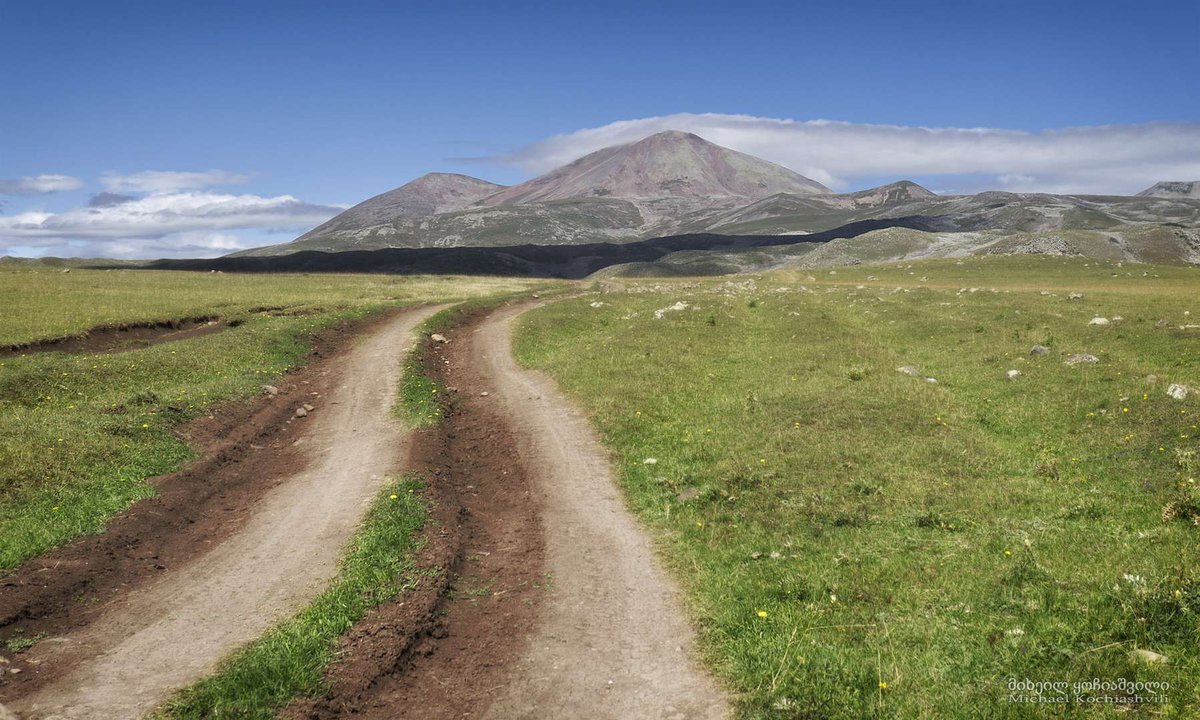
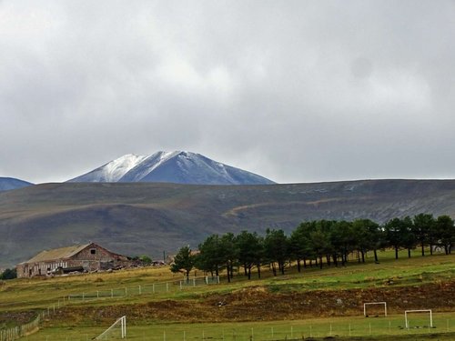
Didi Abuli is built mainly of Neogene hyalodacites, volcanic rock. It's an extinct volcano, and its cone has lost its regular shape through age and sheer height: instead of a neat triangle you'll see a massive rounded dome with wide fields of broken volcanic rock. That's exactly what sets the Javakheti mountains apart from the Greater Caucasus: there it's granite and ice, here it's cooled lava and soft outlines.

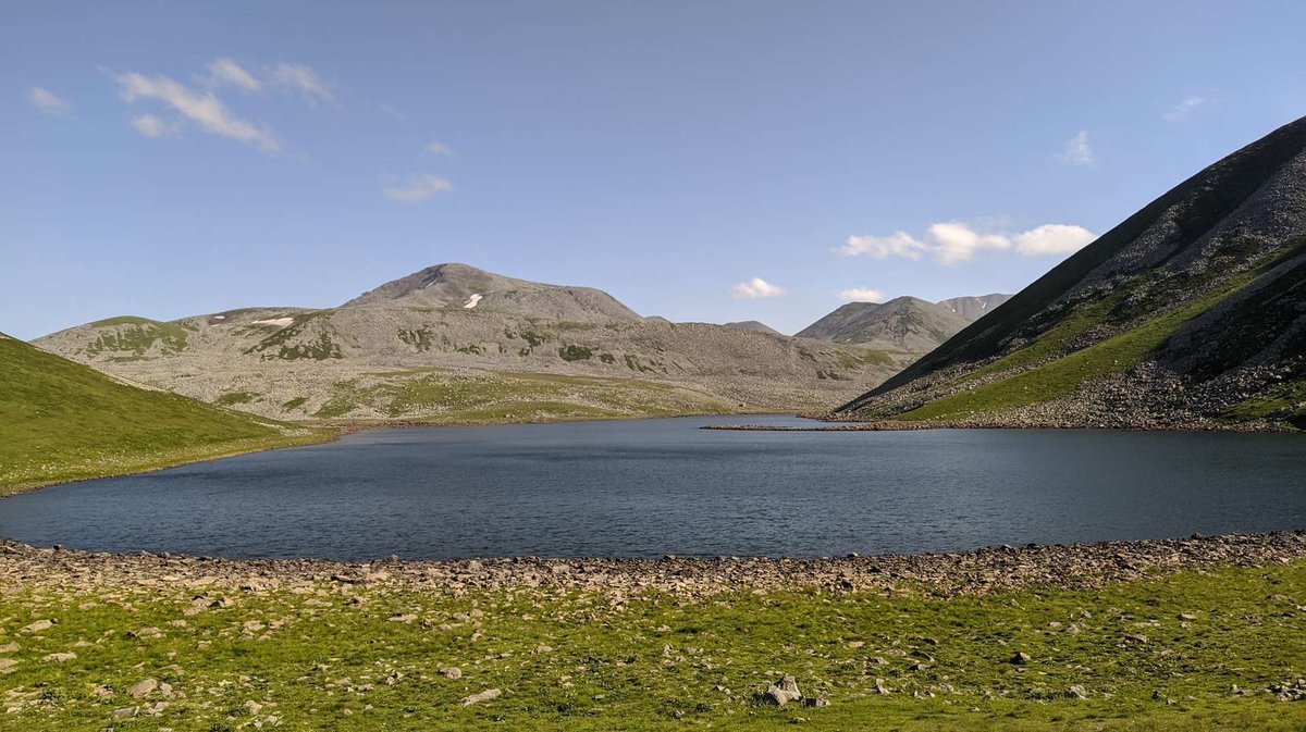
Traces of ancient glaciation survive on the slopes: glacial cirques, moraine ridges and small lakes. Most of the mountain is covered in alpine meadows, and in summer the slopes are in flower.

Didi Abuli is the principal summit of the Samsari range but not the only notable one. Alongside it stand Samsari (3,284.7 m), Godorebi (3,189 m), Kizildagh (3,098.6 m), Karadagh (3,046.9 m) and, importantly for navigation, Patara Abuli, or Little Abuli (2,799.8 m). Don't mix them up: Greater and Little Abuli are two different peaks.

🥇
3,301 m
Highest point of the range
🏔️
Samsari
The second peak, 3,284.7 m
↔️
Patara Abuli
Little Abuli, 2,799.8 m
🗿
Fortress
Megaliths on the massif's slopes

🥾 The Climb: What to Expect

Гора Диди Абули

Technically the ascent of Didi Abuli is undemanding: it's a long trek rather than mountaineering, over open slope. No special equipment is needed in the summer season, there's no scrambling, and the going is over alpine meadows and screes of volcanic rock.

The difficulty lies elsewhere, and it gets underestimated. First, the elevation gain: the surrounding plateau sits at around two thousand metres, so you're climbing more than a kilometre vertically. Second, the altitude itself: at 3,300 metres the air is noticeably thin and your pace will drop. Third, and most importantly, there's nowhere to shelter on the slope. Javakheti is treeless country: no trees, no buildings, no natural protection from wind, sun or storms.

There's no marked trail to the summit. People generally follow worn shepherds' paths and navigate by bearing towards the summit dome, which is visible from far off. Check the starting point and the state of the access roads locally: the dirt tracks across the plateau change from season to season.

👁️ The View From the Top
Гора Диди Абули

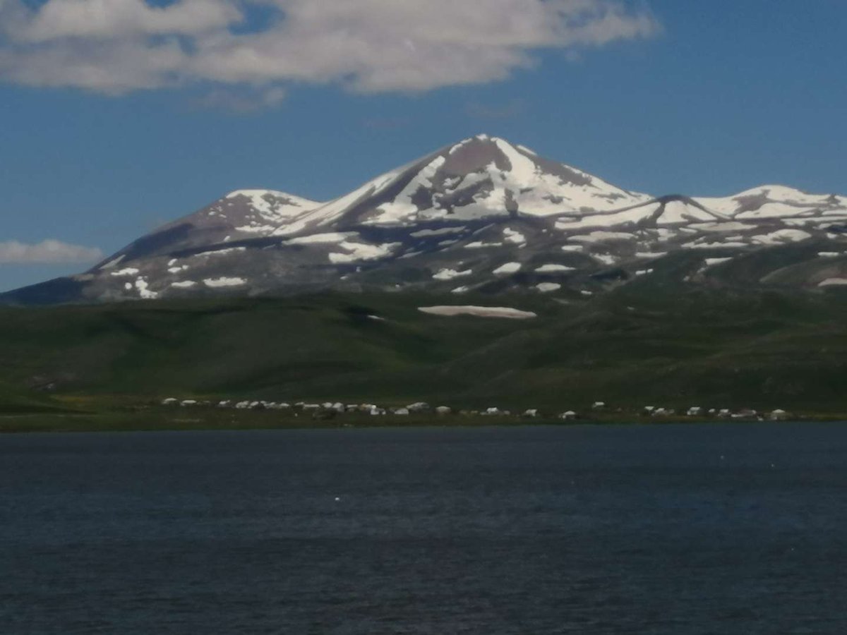
This is what people come for. Didi Abuli stands in the middle of an open plateau with nothing to block the view, so the panorama comes out full circle.

From the summit you can see the lake system of Javakheti: in clear weather Paravani, Georgia's largest lake, is picked out along with the plateau's other waters. You'll see the neighbouring volcanic cones of the Samsari range, the steppe running to the horizon and, with good visibility, mountains beyond Georgia's borders towards Armenia and Turkey. It's a rare view for this country: not gorges and walls, but enormous open space.

On the slopes of the massif stands Abuli fortress, a megalithic structure of basalt blocks laid without mortar. Many people combine the climb with a look at it; we covered the fortress itself in Abuli Fortress.

🌦️ Weather and Season: The Safety Part

⚠️ What to Sort Out Before Setting Off

The Javakheti plateau is the coldest inhabited part of Georgia. An altitude of 3,301 m adds wind and sharp swings on top of that.

1Check the forecast on the day: weather on the plateau changes within the hour
2Nobody goes up in a thunderstorm: it's an open dome with no shelter
3A windproof layer is essential even in July
4The sun is strong at altitude, so bring cream and a hat
5Carry your own water: there may be no springs on the way up
6Outside summer there's snow on the slopes and the route gets far harder

The best window runs from late June to September, once the snow has gone and the ground is dry. That's when the slopes are covered in flowering meadow and the climb looks the way it does in all the photographs. May and October are possible but harder, and depend on how much snow a given year has left.

A word specifically about the weather. It's worth understanding that the forecast for Akhalkalaki and the forecast for the summit are two different things. There's more than a kilometre of altitude between them, and the dome can be ten degrees colder with a strong wind while it's dead calm below. Use mountain forecasts tied to elevation rather than town forecasts.

🚗 How to Get There
Гора Диди Абули

The base town is Akhalkalaki, the administrative centre of the municipality. From there you drive to the foot of the massif on plateau roads, some of them unpaved and prone to turning to mud in wet weather. There's no public transport to the mountain, so you'll need your own vehicle or an arrangement with locals.

It makes sense to take in the plateau's lakes on the way: Paravani is right there, and the whole spread of lakes is covered in The Javakheti Lakes. For how the highland and its cones formed in the first place, see Volcanoes of Javakheti.

🗺️ Didi Abuli and Abuli Fortress on the Map The summit and the megalithic fortress on the massif's slopes.
🗺️ Open OpenStreetMap. The summit sits on the Samsari range, with Abuli fortress to the south on the massif's slopes. There's no marked trail to the top; check the starting point locally.

🧭 Where to Stay

Akhalkalaki is the base. Ninotsminda works too if you're planning to take in the southern lakes.
Find the best hotels, guesthouses, restaurants and cafés across Georgia. Discover comfortable places to stay, authentic Georgian cuisine and useful travel recommendations for every region.

Climbed Didi Abuli? Leave a review on Madloba: tell us where you started, how long the ascent took, what the weather did and what was visible from the top. Your experience will be a real help to anyone planning the climb.

Information is current as of July 2026. Road conditions on the plateau, snow cover and weather all change; always check a current mountain forecast before setting out.
📚 Read Next
Abuli Fortress: megaliths on the slopes of the massif.
The Javakheti Lakes: what you can see from the summit.
Volcanoes of Javakheti: how the highland was formed.
Akhalkalaki: the base for the climb.

❓ Frequently Asked Questions

❓ 📍 Where is Mount Didi Abuli?

💬 In Samtskhe-Javakheti, Akhalkalaki municipality, on the Samsari range in the eastern part of the Javakheti volcanic plateau. The nearest town is Akhalkalaki.

❓ 📏 How high is Didi Abuli?

💬 3,301 metres above sea level. It's the highest point of the Samsari range and of the whole Javakheti highland, whose elevations run from 1,500 to 3,300 metres.

❓ 🌋 Is it an active volcano?

💬 No, it's extinct. The mountain is built mainly of Neogene hyalodacites, and its volcanic cone has lost its regular shape through age and sheer height.

❓ 🥾 How hard is the climb?

💬 Technically it isn't hard: this is trekking rather than mountaineering, with no scrambling. The difficulty is elsewhere, over a kilometre of ascent, thin air and a completely exposed slope with no shelter.

❓ 🗓️ When is the best time to go?

💬 Late June to September, once the snow has gone and the slopes are dry. Outside that season there's snow on the slopes and the route becomes far more demanding.

❓ 🌦️ How do you check the weather on the summit?

💬 Use mountain forecasts tied to elevation rather than the forecast for Akhalkalaki. There's more than a kilometre of altitude between them, so the summit can be ten degrees colder with a strong wind while it's calm below.

❓ 👁️ What can you see from the top?

💬 A full-circle panorama of the plateau: the Javakheti lakes including Paravani, the neighbouring volcanic cones of the Samsari range and, in good visibility, mountains towards Armenia and Turkey.

❓ ↔️ What's the difference between Didi Abuli and Patara Abuli?

💬 They're two separate peaks of the same massif. Didi Abuli, Greater Abuli, is 3,301 m; Patara Abuli, Little Abuli, is 2,799.8 m. They're easy to confuse when planning a route.

Alla Smirnova
By:

Alla Smirnova

Post: Georgia sightseeing expert

My name is Alla Smirnova, and I am completely enchanted by Georgia. My passion is to share the amazing stories and rich ancient culture of this country. As an…

Visit author

31 comments


Log in to leave a comment


  • L
    Lucia Garcia
    No puedo evitar pensar en lo asombroso que es caminar sobre un antiguo volcán. La idea de estar en Didi Abuli, mirando desde más de 3,300 metros de altura, me da un cosquilleo en el estómago. Pero, ¿qué tal el clima en esta época del año? A veces los planes de montaña se desmoronan con una tormenta. He estado soñando con un viaje a Georgia y esta ruta suena perfecta, pero me pregunto cómo se siente realmente esa subida empinada. ¿Es agotadora o la vista lo compensa todo? Gracias por compartir esta experiencia, ¡espero vivirla pronto!
  • M
    Maximo
    Дорогие друзья! Хочу поделиться эмоциями после прочтения очень вдохновляющего рейтинга на Мадлоба про Диди Абули и горный хребет Абул‑Самсари — это по‑настоящему магические уголки Самцхе‑Джавахети, которые уже давно вошли в мой список обязательных маршрутов! Эти древние горы словно вырастают из земли и притягивают взгляд своими альпийскими лугами, кристально чистыми озёрами и величественной тишиной, которую невозможно забыть.

    Самая высокая вершина здесь — гора Диди Абули, достигающая более 3300 м над уровнем моря, откуда открываются невероятные панорамы на весь регион; путь к ней занимает примерно два часа пешего восхождения — и каждый шаг стоит этих видов!

    Хребет Абул‑Самсари окружён ледниковыми озёрами вроде Табацакури и Левани, а на его пастбищах мирно пасутся овцы под охраной сторожевых псов — атмосфера здесь умиротворяет и зовёт остаться ещё на день или два, наслаждаясь тишиной природы.

    Советы местных в рейтинге помогают понять, где лучше начинать маршрут, как безопасно добраться до подножия гор и на что стоит обратить внимание в пути — это делает прогулку вдоль древних склонов ещё более продуманной и приятной.

    Я уже мечтаю вернуться сюда на рассвет, чтобы увидеть, как первые лучи солнца играют на озёрах и горах. А вы готовы отправиться в такой маршрут, чтобы увидеть Абул‑Самсари и Диди Абули собственными глазами — пешком или на джипе? Спасибо каталогу мадлобу за то, что есть такие рейтинги!
  • S
    Savannah Falconer
    The majestic views on the way to Didi Abuli are breathtaking, and I highly recommend bringing extra water for the hike since there are no springs along the path.
  • მ
    მაია წულუკიძე
    დაზიებული დისყავით ადალი, დღომდე წალკ ყამეტს ვრება მებერში, სადაც სასამართლოს პარკეტუზარა სამუდამოდ ეტის ვისნების ყადლითად, მენი ტურის ვიზალაძის მენი ტურის მცირედით მბუდარმაეთვს სისები.
  • Z
    Zinaida
    Статья заинтересовала меня таинственными видами гор и ледниковых озер, а также хочется узнать больше о маршруте для джипов, чтобы оценить возможность поездки в будущем.
  • E
    Edeline Moorfield
    Is there a specific time of year that’s best for visiting the mountain and the lakes nearby? I’m wondering if the views and accessibility vary throughout the seasons.
  • l
    lena4ordeev
    Какой вид транспорта лучше выбрать, если на джипе добираться удобнее?
  • L
    Lia Nadareishvili
    შესანიშნავია, რომ სამცხე-ჯავახეთის მთების სილამაზე ასე დეტალურად არის აღწერილი. მაინტერესებს, შესაძლებელია თუ არა გზის გავლა ჩვეულებრივ მანქანით, თუ 4x4 ნამდვილად აუცილებელია ამ მარშრუტისთვის? ასევე, სიცივეში როგორ პირობებია, მაგალითად შემოდგომისას, როდესაც აპირებ მოგზაურობას?
  • R
    Rickey Wallace
    The stunning views and serene mountain lakes along the trail from Vladimirovka to the base of Didi Abuli make the journey absolutely worthwhile.
  • Ю
    Юрий Орлов
    Не совсем ясно, почему восхождение на Диди Абули занимает всего два часа, если гора считается неприступной. Может быть, речь идет только о самом подъеме, а не о всей сложности маршрута? Или есть более удобные тропы, которые и позволяют добраться так быстро?
  • ბ
    ბექა ჟორჟოლიანი
    ალპური მდელოებითა და სუფთა მთის ტბებით გარშემორტყმული დიდი აბული ნამდვილად ღირს მოგზაურობისთვის!
  • К
    Кира
    Какие красивые пейзажи и виды на озера, мечтаю побывать на такой прогулке и насладиться этой природой.
  • T
    Tariel
    როგორ შეიძლება დავგეგმო ვიზიტი ვლადიმიროვკიდან დიდი აბულის წვერზე, თუ არ მაქვს ჯიპი? ასევე, რომელია საუკეთესო პერიოდი წელი ასვლისთვის, რომ მოვასწრო ალპურ მდელოებზე თვალის ნამდვილად მოხიბვლა?
  • S
    Stetson Yardley
    Sounds like a wonderful adventure. The climb to the top of Didi Abuli seems manageable, but I appreciate the reminder to bring enough water. The mention of alpine meadows and crystal-clear lakes around makes me curious; I'd love to witness sheep herds with loyal guardian dogs by their side. Starting the journey from Vladimirovka and the use of a jeep to reach the base adds a sense of thrill. Those scenic views of mountains conversing with the sky must be breathtaking.
  • თ
    თემური
    რატომ არის აუცილებელი წყლის მარაგის გათვალისწინება, თუ წყაროები არ არის მთასთან? როგორია საუკეთესო პერიოდი ამ გზის გასავლელად, რომალპიურ ფაქტორს გამოვექცეთ?
  • Л
    Лали Дзамбулатова
    Сколько занимает дорога от деревни Владимировка до подножья гор на джипе? Интересно, есть ли организованные экскурсии в этот район, чтобы насладиться природой и не переживать о логистике.
  • M
    Melusine
    Do the sheep dogs around the lakes pose any threat to tourists? I love hiking, but I'm a bit concerned about encountering them on the trails.
  • С
    Света Белова
    Посещала Самцхе-Джавахети прошлым летом. Подъем на Диди Абули действительно занял у меня около двух часов, но без запаса воды было бы сложно. Вид с вершины захватывающий, особенно впечатляют альпийские луга и горные озера. Впервые попробовала доехать до подножья на джипе — это оказалось отличным решением для комфортного путешествия. Рекомендую всем, кто не боится немного напрячься ради таких видов.
  • С
    Света Белова
    Посещала Самцхе-Джавахети прошлым летом. Подъем на Диди Абули действительно занял у меня около двух часов, но без запаса воды было бы сложно. Вид с вершины захватывающий, особенно впечатляют альпийские луга и горные озера. Впервые попробовала доехать до подножья на джипе — это оказалось отличным решением для комфортного путешествия. Рекомендую всем, кто не боится немного напрячься ради таких видов.
  • С
    Света Белова
    Посещала Самцхе-Джавахети прошлым летом. Подъем на Диди Абули действительно занял у меня около двух часов, но без запаса воды было бы сложно. Вид с вершины захватывающий, особенно впечатляют альпийские луга и горные озера. Впервые попробовала доехать до подножья на джипе — это оказалось отличным решением для комфортного путешествия. Рекомендую всем, кто не боится немного напрячься ради таких видов.
  • N
    Nelson Blackwood
    The journey to the summit of Didi Abuli sounds incredible, especially with the backdrop of pristine alpine meadows and clear mountain lakes. Tackling the climb in about two hours seems manageable, but it's good to know that carrying extra water is essential due to the lack of springs. The thought of seeing sheep grazing by the glacier lakes at the foot of Abul-Samsari adds a rustic charm. The route from Vladimirovka must offer some breathtaking views. Thanks for sharing this insightful detail; it makes planning a visit much easier.
  • S
    StanislavZ35y
    Могу посоветовать добавить важный момент: стоит ли брать с собой треккинговую обувь для восхождения на Диди Абули? Сложность маршрута иногда требует особой подготовки. С этим намного легче справиться, особенно если тропа каменистая или скользкая.
  • И
    Игорь
    Диди-Абул и горный хребет Абул-Самсари — это настоящая жемчужина среди природных достопримечательностей Грузии! Эти места — идеальный выбор для тех, кто хочет насладиться величием гор и альпийских луг. Пейзажи просто захватывают дух, особенно виды с вершины Диди Абули. Кристально чистые озера и альпийская флора создают невероятную атмосферу, которая останется в памяти надолго. Хоть маршрут и несложный, для полной безопасности лучше брать с собой воду и быть готовым к некоторым сложным участкам пути. Абул-Самсари с его ледниковыми озерами и пастбищами — место, где хочется задержаться и насладиться моментом тишины и красоты!
  • G
    G_elel
    Мои воспоминания о путешествии по Диди-Абул и горному хребту Абул-Самсари навсегда останутся в сердце. Этот маршрут прошел через величественные альпийские луга и кристально чистые озера, среди которых я чувствовала себя частью настоящего рая. Поднявшись на вершину Диди Абули, открылся захватывающий вид на Самцхе-Джавахети, который невозможно забыть. Прекрасные озера Табацакури и Левани у подножья хребта Абул-Самсари, пасущиеся овцы и величественные горы сделали это путешествие незабываемым. Это по-настоящему одно из самых красивых мест Грузии, которое стоит увидеть каждому туристу.
  • Е
    Елена
    Маршрут Абул-Самсари и Диди Абули — это настоящее путешествие в сердце природы Грузии! Альпийские луга и озера с кристально чистой водой создают незабываемые пейзажи. На протяжении всего трека вас будут окружать самые красивые места, которые подарят вдохновение и умиротворение. Идеальный выбор для любителей природы и приключений!
  • a
    alishertoktar8
    Среди величественных горных вершин Грузии расположена Диди Абули, словно алмаз в сердце природы. Описание этого места заставляет сердце биться быстрее от ожидания увидеть его красоту. Прогулка к вершине обещает незабываемые впечатления, но требует осторожности и подготовки. Раскрывается перед глазами картинка бесконечной красоты: снежные вершины, ледниковые озера, стада овец на зеленых лугах. Это место — идеальное приключение для тех, кто ищет соприкосновение с величием природы.
  • K
    Kira
    Да что и говорить -лучше гор могут быть только горы,на которых ещё не бывал! Автор знакомит нас с увлекательными маршрутами,даёт полезные советы перед путешествием.Спасибо огромные!
  • A
    Anno
    Благодаря опыту авторов статьи, читатель может получить много полезных советов о том, как подойти к треку, чтобы обеспечить комфорт и безопасность в походе. Описания основных достопримечательностей позволяют читателю лучше понимать историю и культуру региона, что делает статью еще более красочной и интересной. В общем, статья о походе на Абил-Самсари и Диди-Абули выглядит очень привлекательной и захватывающей. Спасибо автору!
  • b
    bikteeva94
    Путь к вершине Диди Абули составляет два часа ходьбы, это мало, но нужно быть очень осторожным и обязательно взять с собой запас питьевой воды, так как на склонах горы нет родников. Спасибо автору за такую полезную информацию о красивых местах! Покорять горы, пусть даже не сложные, это уже подвиг, я считаю!
  • k
    klimovadominika47
    Влада, добрый вечер. Хочу Вас убедить в том, что природа Грузии сама по себе очень разнообразная. Поэтому меня впечатляет до глубины души самая маленькая достопримечательность. Я имею в виду: начиная от маленьких статуй и памятников и заканчивая до огромнейших водопадов и монументальных гор. Хочется все объездить.
  • В
    Влада
    Вид на самом деле очень живописный. В буквальном смысле. Бери мольберт, садись и пиши пейзаж у подножия Древних Гор. Может они и не впечатляют заснеженными вершинными, но они дают такое умиротворяющее чувство. Красота и покой, тишина и нерушимость. И пусть пейзажи будут разные. На рассвете в растворяющем тумане, на закате в обжигающем красно-багровых пожаре облаков. В хрустальный полдень, когда тени исчезают, и все объекты словно омыты светом. В полнолуние, когда очертания гор лишь угадываются, а правят бал звёзды, такие близкие к нам в горах. Мне нравится мыслить образами, а природа Грузии этому несомненно способствует. На фото заснеженной вершины Диди Абули не видно, но мне очень нравится этот пейзаж.