




Abukhalo Rock in Dzama Gorge: Fortified Caves and 20 m Waterfall
The Dzama River originates on the northern slope of the Trialet Range, at an altitude of 2,140 meters above sea level. On the way it merges with several rivers and near Kareli, on the right side, joins the Kura. Despite the fact that the valley is quite high above sea level, for many centuries it has been densely inhabited.
Many cultural monuments have survived in the valley: the architectural complex of Kozifa (Gugomi) consisting of five churches (Tkemlovani river valley); a convent and towers in Ortubani; the oldest churches and monasteries of Gverdzineti; the monastery complex and the Sarkineti monastery carved in a rock near the settlement Elbakiani; the monastery in Kveda Shuan (1800 m above sea level) and others.
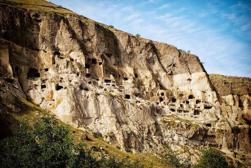
Among these monuments, the complex carved in the Abukhalo rock deserves special attention. The Abuhalo rock massif itself is a unique natural formation.
The complex, dated XII-XIII centuries, is a defensive building, where the population took shelter during the enemy invasions. The complex consists of 8 caves of different sizes which are connected with each other by hollows and passages. Some of the caves have plastered and whitewashed walls, and those facing the hollow have loopholes. You can get there only from the east and west sides.
At the edge of the Abukhalo-Kareli highway, at the distance of 1 kilometer from the Abukhalo massif, there is a beautiful 16-meter waterfall on the Abukhalo River. A second, 20-meter waterfall is located 3 kilometers to the west of the complex, on the right tributary of the Abukhalo River. A hiking trail ascends from the valley to Mount Bardzimjvari (2,255 m), which offers a magnificent panorama of the landscapes of Shida Kartli.
Location:
Kareli Municipality (Zguderi community), source of the Dzama River; northern slope of the Trialeti Ridge; at an altitude of 1,158 meters above sea level.
Coordinates:
41°48′01″N; 43°44′55″E.
How to get there:
Located 6 km from the Kozifa junction. A steep 400 m trail leads up the slope. Distance: from Tbilisi — 130 km, from Kareli — 35 km.

39 comments
Log in to leave a comment
Меня особенно впечатлило, как в рейтинге описано происхождение и особенности Абухало — огромная скала, стоящая над долиной реки Чорохи, с панорамными видами на окрестные горы и леса. Такой природный «балкон» становится идеальной остановкой для фотографий, пикников и просто наслаждения тишиной и мощью гор. 🌄 (madloba.info)
Очень важно, что в статье есть практические советы от местных жителей: где лучше оставить машину, как подготовиться к небольшой прогулке до вершины и на что обратить внимание в зависимости от сезона. Такие детали помогают путешествию быть не только красивым, но и комфортным. Плюс — отзывы других читателей и ответы на часто задаваемые вопросы! Это реально экономит время при планировании и даёт уверенность, что ты движешься в нужном направлении. 🙌
Теперь я всерьёз хочу добавить Скалу Абухало в свой маршрут, особенно если получится совместить это с посещением близлежащих горных рек и источников.
А вы уже были на Абухало или других подобных скалах в Грузии? Какие виды там впечатлили вас больше всего? 😊
Я также обратила внимание на водопады в этом районе. Великолепный 16-метровый водопад на реке Абухалосцкали и еще один, 20-метровый. Я уверена, что пейзажи Шида Картли, открывающиеся с горы Бардзимджвари (2255 м), могут захватить дух своей красотой. Я благодарна авторам статьи за то, что они поделились этой информацией и дали возможность многим узнать больше о таком замечательном месте. Я надеюсь, что многие люди смогут посетить эту долину и насладиться ее красотами.
Данный комплекс состоит из восьми пещер, и в свое время являлся оборонительным сооружением. Также недалеко от Абухало находятся несколько водопадов, самый высокий - двадцатиметровый!