




Lava Flow Abduli
The name "Abuli" in the Samtskhe-Javakheti region is given to two mountains (Patara and Didi Abuli), a lake, a village, a river and a cyclopean fortress on Mount Patara Abuli.
Lava Stream is included in the list of natural wonders of Georgia. The stream begins from the mountain Didi Abuli, which is located on the Abul-Samsar range. The height of Didi Abuli is 3303 meters. The mountain is an extinct volcano, the cone is deformed because of its antiquity and great height.
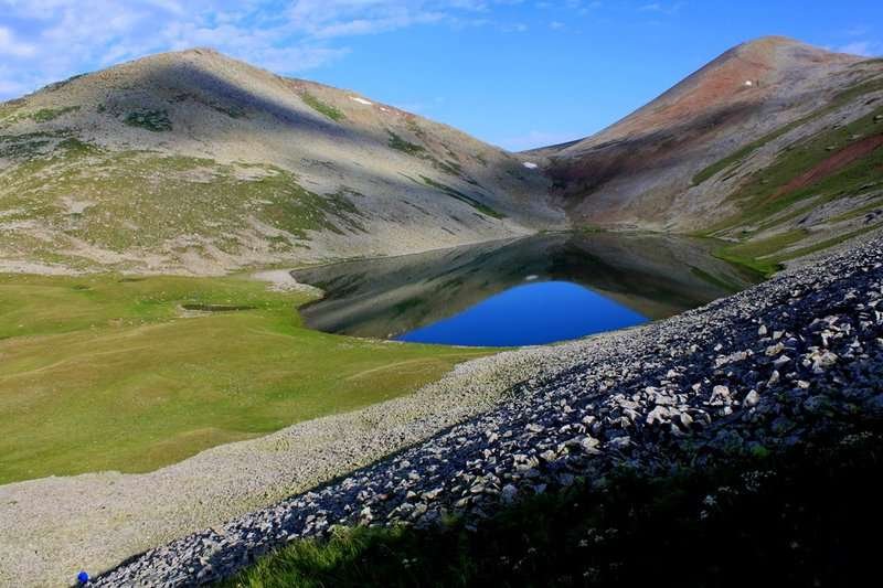
South of Didi Abuli is Mount Patara Abuli (2800). The slopes of the mountain and its foot are covered with "stone seas". There are several lakes in the central part of the lava flow.
The southern slope of Mount Patara Abuli is covered with large rocks, brought down by old glaciers. On this slope at an altitude of 2670 m above sea level is a cyclopean dry masonry fortress. The fortress is notable for its size, power, impregnability, and strategic location. In spite of the fact that the fortress was built of flat stones, without using cement, the height of walls in some places reaches 5 m, thickness - 3 m, the area of an internal fortress - 2400 sq.m. The builders cleverly took advantage of the presence of a large number of boulders here, and by rearranging some of them, arranged underground shelters with a narrow and low loophole closed by boulders. That is why it is almost impossible to detect the entrance in the mass of a large number of huge stones.
At the foot of the northeastern slope of Mount Samsara, near Baraleti, a cool breeze blows in hot weather from the lava clefts, which are at a height of 2200 m. This indicates the existence of underground cavities (lava caves) in the lavas, filled with air. On hot summer days, sheep flocks near the clefts to cool off.
Location:
Akhalkalaki Municipality, basin of the Paravnis Tsqali River, at an altitude of 1,991 meters above sea level.
Coordinates:
41°02′24″N; 43°01′07″E.
How to get there:
A dirt road leads to the fortress through the village of Abuli (Akhalkalaki Municipality). The road is suitable for high-clearance vehicles. Distance from the village to Abuli Fortress — 17 km. Locals use a shorter route via the village of Ganzani (Ninotsminda Municipality); hiking distance — 10 km. Distance: from Tbilisi (via Ganzani) — 150 km, from Akhalkalaki — 28 km, from Akhaltsikhe — 100 km.

41 comments
Log in to leave a comment
بس بعد ما طلعنا فوق، حسيت برغبة قوية أكتشف بس بنفس الوقت أشعر بالخوف، من قوة المكان! الكل كان يتحدث عن الحصن الرائع، وفعلاً كان هيك مثير! اللحظة اللي وصلت فيها لأعلى قمة، حسيت كأنني أعيش جزء من التاريخ، لكن في نفس الوقت، إيش لو كان في شي غريب بانتظارنا هناك؟
هل جربت تصعد لجبل أبولي؟ شنو كان شعورك؟
Мне особенно нравится, что в статье подробно описаны тропы и советы от местных 👣💬 Благодаря этому сразу ясно, куда идти, где сделать лучшие фото и какие чудеса вокруг себя заметить первым 📸. После прогулки вокруг лавового потока обязательно хочется заглянуть в уютное кафе ☕🍰, обсудить впечатления с друзьями за чашечкой ароматного кофе и бокалом грузинского вина 🍷 — что может быть лучше после такого приключения? 🌄💛
Такой рейтинг даёт не только красивые виды, но и ощущение места ещё до поездки, с полезными подсказками и отзывами настоящих путешественников 🌿✨
А вы уже видели лавовый поток Абдули? Какие места вокруг него вам особенно понравились — и в какое время года, по вашему мнению, здесь особенно эффектно? 🌞🗺️🔥
кан действовал и лава текла рекой.С интересом прочитала эту публикацию и была поражена информацией о циклопический крепости,масш-
табы крепости впечатляют.А почему такое название -циклопическая?Сколько я не знаю оказывается.С большим интересом прочла статью