




Mestiachala Hiking Route: Glacier, River and Trail
Surrounded by mountains, at 1500 meters above sea level stands the city of Mestia, the administrative and tourist center of Zemo Svaneti. It is located in the Mestia Hollow, on the banks of the Mestiachala and Malkhri rivers.
Mestiachala River originates from the waters of Lehziri and Chalaati glaciers. At the settlement of Mestia the river from the right side merges with the river Mulkhra. The length of the Mestiachala is 11 km, the area of the basin is 152 sq km. In the valley of the Mestiachala is the longest glacier in Georgia - Lehziri. Lekhziri is a valley-type glacier, located on the southern slope of the Svan section of the Greater Caucasus Range, in the Inguri River basin. The tongue of the glacier descends to 1950 m. Numerous streams of meltwater flow out of it, which in the middle section gather into two drainless lakes. The glacier is fed by ice streams and landslides coming down from the peaks of the Bashil, Laikh, Marianaga, Dzhantugan, Ulukar, Bjedukh and Dalakor slopes.
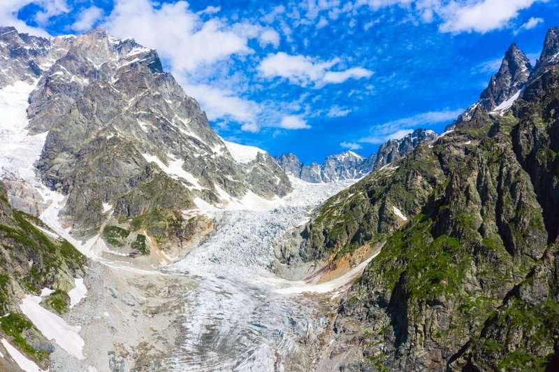
One of the sources of the Mestiachala River is the Chalaati glacier, the only glacier on the southern slope of the Caucasus Range. It crosses the forest zone and descends lower than all the glaciers. The height of the glacier tongue is 1880 m. Chalaati belongs to the valley type of glaciers. It descends on the southern slope of the Svan section of the Greater Caucasus Range (length - 7.2 km, area - 12.15 sq km).
The valley of Mestiachal is a real kingdom of ice blocks, brought by glaciers. One of these blocks in the form of a column rises in the river bed on its surface grows several firs. The block is over 15 meters in diameter. The second fallen boulder supports a metal suspension bridge. To get to the Chalaati Glacier on the hiking route, you must pass this bridge. The hiking trail leads to a coniferous forest and then leads to a plain overgrown with bushes and flowers.
Location:
Mestia Municipality, southern slope of the Svan section of the Greater Caucasus Range.
Coordinates:
43°06′34″N; 42°44′37″E (Mestiachala glacial boulder).
How to get there:
From the town of Mestia, a rocky road leads to the Mestiachala River, from where you need to walk to the glacial boulder. A hiking route then begins toward the Chalaati Glacier. Access to the Lekhziri Glacier is difficult and requires mountaineering equipment. Distance: from Mestiachala Glacier to Lekhziri — 6 km, to Chalaati Glacier — 3 km; from Tbilisi — 500 km, from Zugdidi — 150 km.

37 comments
Log in to leave a comment
Hiking deneyimim sırasında, Lehziri buzulunun yanında otururken, buzulun sesi adeta bir müzik gibi gelmişti. Ama bazen, o güzel manzaraya dalıp gitmek yerine, insanlarla sürekli çarpışmak da sinir bozucu olabiliyor. Oraları biraz daha korumak gerekmez mi?
Son olarak, zamanlama hakkında bir sorum var: Glaciera ne zaman en iyi ziyaret edilir? Farklı mevsimlerdeki deneyimler hakkında bilgi verirseniz çok sevinirim!
Особенно вдохновляют советы от местных 👣💬 — они подсказывают, где искать лучшие виды, какие тропы выбрать, чтобы увидеть самые живописные уголки, и как сделать прогулку максимально насыщенной 📸✨ Эти подсказки делают подготовку к путешествию куда интереснее и помогают почувствовать атмосферу долины ещё до поездки! 💛
После прогулки по долине так приятно представить, как ты зайдёшь в уютное кафе ☕🍰, обсудишь впечатления с друзьями за чашкой ароматного кофе и бокалом грузинского вина 🍷 — идеальный способ завершить день среди природы! 🌞🌿
Мне очень нравится, как этот рейтинг помогает прочувствовать дух Местиачалы: живые описания, реальные отзывы и полезные лайфхаки делают путешествие настоящим удовольствием 🌍✨
А вы уже были в долине Местиачала? Какие места или виды там впечатлили вас больше всего, и в какое время года, по вашему мнению, сюда стоит отправляться, чтобы увидеть всю красоту природы? 🏞️💚