
Add organization

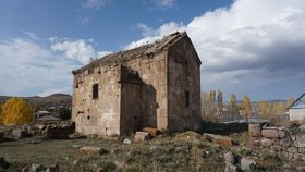
The Megreki Shrine near Ikhtila Village

Unknown
Updated at:
5.0/1 review
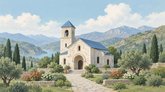
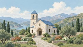
Иллюстрация церкви: светлое каменное здание с колокольней и синей крышей, дорожка, цветы и горный пейзаж.
  • General
  • Description
📍 Coords and Plus Code

The place is known under the name Megreki and is marked as a place of worship near Ikhtila village. Open records do not specify the type of building or the dedication, so only the name is given.

Ikhtila lies on the Javakheti plateau east of Akhalkalaki, among pastures and rocky ridges. The country is open, and coordinates are the easier guide here.

The last kilometres of the road run along a dirt track. Wear closed shoes: the grass is tall and stones lie underfoot.

📌 In brief

  • The place is known under the name Megreki
  • Marked as a place of worship near Ikhtila village
  • Coordinates are the easier guide here

🚗 Getting there

  • Near Ikhtila village, Akhalkalaki Municipality; about 18 km to Akhalkalaki
  • The navigator opens with the Build Route button

✍️ If you have made it here, tell about it in a review - your experience will help others.
Location map
Click to load interactive map

Similar places nearby

Places in the same category within 5 km. Distances are approximate and measured in a straight line.

1 review
Give a rating
Upload photos
  • Z
    Zura Chitaia

    მე-10 საუკუნის ქართული მართლმადიდებლური სამონასტრო კომპლექსი მოიცავს ტაძარს, ნაშთების ნაწილებს და გალავანს. მთავარი ტაძარი აშენებულია დამუშავებული ყვითელი ქვის კვადრებით, თუმცა მას ახლა სერიოზული დაზიანებები აქვს. მონასტრის სხვა ნაგებობები მხოლოდ საძირკვლის konturებს წარმოაჩენს, ხოლო მათი დანიშნულების გაგება არქეოლოგიური გათხრების გარეშე შეუძლებელია.