


Walking route to Lake Tkibuli in Kintrishinsky National Park - sights of Georgia in Adjara.
One of the most beautiful places in Georgia is the high-mountain lake Tkibuli in the Kintrishinsky National Park. The altitude is 2230 above sea level. The track route passes through the Echo Village Valley, near Mount Hino. If you are lucky, you will meet a Caucasian newt in these places
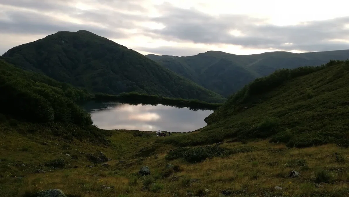
Lake Tbikeli is located in the western historical region of Adjara, and is located on the territory of Kintrishinsky National Park. The reservoir is interesting for its location, it rises 2222 m above sea level, as it is located on the slope of Mount Nabadziri. Lake Tkibeli is not the deepest – its average depth is only 8-10 m–
It gets its food from the mountain groundwater of Nabadzine, rain and melt water, which is why it is one of the cleanest lakes in the region, there is definitely something to see in Georgia. The fresh waters of the lake are the habitat of the red-book Caucasian newt. The best time to visit the reservoir is the velvet season: from August to September or in late spring, in May.
Приглашаем для общения про Грузию


Sights of Georgia they are often located in remote places where you can enjoy untouched nature, tranquility and tranquility. The route to the lake is a wonderful opportunity to enjoy a walk along the picturesque slopes and feel like a real discoverer of these unique places. The path to Nabadzini begins at the southern valley of Ahoseila and leads to the west – to Mount Hino. The road is clearly visible, and its overcoming is not difficult even for an unprepared tourist, the path goes along the slope of the mountains and crosses the slope of Hino from the south, the descent from the hill runs along the mountains of Hino and Sarbiela, namely: along the ridge connecting them. Then the road crosses the Sarbiela mountain from the south side and goes to the ridge.
To get to the lake, you can turn towards the settlement of Hino, which is located 1.3 km above sea level, but it should be borne in mind that the descent along the ridge is quite time–consuming and difficult, especially for beginners. Therefore, there are still alternative ways to reach Lake Tbikeli. The map shows the routes on the northern and lower western side. The western slope is much easier and any traveler can overcome it.
The lower path along the foot of the mountain goes next to a wooden hut, where you can make a halt or hide from the weather, there is also a source of running water where you can quench your thirst and replenish your supply. After resting in the hut, the path connects with the main road to Mount Narusala, overcoming the mountain range, you get to the western shore of the lake. The lake shore is suitable for setting up a tent. The inhabitants of the lake are friendly amphibious newts, fish are not found in the waters of the lake.
The slope in the west of Mount Narusala is abundantly overgrown with trees and shrubs, it is quite passable, but thin branches can cling to skin and clothing, so you should go on a trip only in clothes that will protect your skin from branches. Well, what a forest without insects, a large number of them live here. Make sure to cover your face in advance if you don't want to be bitten. The camping camp offers an amazing view of the mountain panorama, decorated with crowns of evergreen trees. In the evening, the entire mountain valley is illuminated by sunset rays, this unforgettable view impresses experienced tourists and travelers so much that they consider the territory near Lake Tbikeli to be the most beautiful places of Georgia. However, there are no sources of running water at such points, so you should think about a thermos of water in advance. You can replenish your water supply in a wooden cottage nearby, a thirty-minute walk from the camping camp.
Transport
The first part of the way passes along the road, it can be overcome by any type of transport, you can even get there by taxi. But then you need a car with high traffic, for example, an SUV. You can rent a car and get to your destination via the highway connecting the Habelashvili settlement and Mount Gomi.
--------------------------------------------------------
Photo by Ilia cecxladze


7 comments
Log in to leave a comment